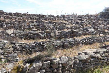
Inventories of Terraced Landscapes in Peru
Affiliations
- 1 Coordinator of ITLA, Honorary Research Fellow of the Center for Agroecology, Water and Resilience, University of Coventry, UK
- 2 Hydrogeologist and Lic. Geologist. Huelva, Spain
- 3 Biologist, AGRORURAL, Min. of Agrarian Development and Irrigation, Lima, Peru
The Journal of Terraced Landscapes volume 1, issue 1, pp. 34–71 (2020) · Cite this article
- 372 views
- 424 downloads
- DOI10.5281/zenodo.5215341

Abstract
The inventory of terraces in Peru in most regions was initiated in 2011 as part of a reconstruction project funded by the IDB and implemented by Agrorural, the extension agency of the Ministry of Agriculture. The aim was to identify areas of agricultural terraces to be rehabilitated as an effort to gain new areas to extend the agricultural frontier. The inventory tried to revise the different efforts of the Natural Resources office ONERN (National Natural Resources Office) from 1987, INRENA (National Institute for Natural Resources) from 1995 and PRONAMACHCS (National Project for Hydrographical Watershed Management and Soil Conservation) from 2004 and complete the available data. The history of inventories for different areas of Peru and the analysis of available maps shows the limitation of the last inventory finished in 2014 as it does not include all existing (in use or abandoned) terraces as there was no observation on the ground and the task was too vast for the GIS team. The total estimation of terraced fields of the Agrorural study arrives at 340,719 ha of terraced fields in Peru (81,367 ha abandoned – only 24 %). Our review shows that the abandoned terraces not detected can be up to 50 % – 100 % considering the available data and analysis. We want to provide insights into the future tasks of further intensifying the inventory of terraced landscapes in cooperation with local communities so that a real recuperation of the best agricultural lands for producing excellent food for the Andean people will be possible.
Keywords
- Peru
- inventory of terraced landscapes
- mapping
- aerial photographs
- remote sensing imagery
- inventory of terraced landscapes
- mapping
- aerial photographs
- remote sensing imagery
Within the context of the world atlas of terraced landscapes as part of the ITLA1 action plan we are interested to contribute with a discussion about inventories of terraces (Andenes in Peruvian Spanish), which have been prepared in Peru to identify their limitations and also the necessary future steps to recover terraced landscapes for the production of quality food. From the decades of developing inventories and the changing technologies from aerial photo to satellite images and GIS (Geographical Information System) we can understand how to approach terraced landscapes and from the limitations we can learn how to focus on terraces, people and their cultures as an archive for the future of humankind. Limitations come from the technology used and often without the people who inhabit terraced landscapes and from the parameters of classifying terraces.
The classification of terraces has a material dimension, an historic dimension and a sociocultural dimension. Aspects like the geographic location, construction material (with stones, or loess), drainage and irrigation, crops have been the main criteria to classify terraces (Mejía, 2014). Then the status of the terrace – is it still in use, is it a perfect construction, is it temporarily fallow land, has it been abandoned and then if it is destroyed, stones have been removed and the horizontal lines are still visible but there has been a collapse of terraces, the decrease of population and destruction of the local society and the production centuries ago. Historically, terraced areas have been created by private initiative, by social groups or by state (local, national) programs (Denevan, 2001). Many areas have been a result of local mountain cultures embedded in their food culture systems and maintained with a body of indigenous or local knowledge (Torres, 2014).
The identification of terraced areas and the building of an inventory create a basis for the discussion of recognition of terraces and their products, and the recuperation of terraced fields through local initiatives organised by the civil society or supported through government programs. Mountain communities are often isolated therefore with the inventories we can identify the social groups and the knowers of terraces and their biodiversity, their cultivation and construction. ITLA has the aim to connect mountain peoples and to provide an exchange of knowledge, an exchange of enthusiasm and the consciousness of becoming part of an international and global movement recovering terraces and their culture (Alberti et al., 2018). The network of ITLA in Peru named Andenes and Food Sovereignty is working for the links between mountain communities and the engagement of academics, young researchers, technicians and also activists from NGOs. The methodology followed is based on the review and contrast of the information referring to previous works of mapping of terraced spaces in Peru. The usefulness of high-resolution satellite images for reviewing inventory results is actively demonstrated. They also allow the detection of other areas with previously undetected terraces. On the other hand, it should be noted that satellite images are easily intuitive for anyone and this favours the establishment of local dialogue processes with communities to discuss the potential of the abandoned terraces.
In this article we want to make a contrast between the previous works of mapping Peruvian terraced landscapes, as well as their limitations, and open the way to the different challenges that the future holds, providing ideas on future tasks to further intensify the inventory of terraced landscapes, in cooperation with local Andean communities, so that a true recovery of a large area of land takes place capable of producing excellent food for humanity, integrating multiple advantages compared to modern models of land management, in terms of sustainability and environmental benefits.
2. Inventories of Terraces in Peru
The terraces of Peru therefore are significant globally because of their extension and the work of art and craftsmanship. They were mentioned by the chroniclers in the 16th century, as the huge stone walls of the Inca2 and Pre-inca societies were technically astonishing and served also as ritual places for the Inca leadership. Also travellers and scientists since then have been writing about terraced lands. O.F. Cook published his observations from the expedition in 1915 with the National Geographic Society naming the terraces of Peru “Stair Case Farms” highlighting the skills and knowledge of the ancient Peruvians describing them as “marvelous terrace agriculture” (Cook, 1916).
2.1 Overview of inventories
A first attempt of an inventory of terraces in the Americas was compiled and published by R.A. Donkin (1979), a British geographer, who visited the Americas studying mountain agriculture from Mexico to Bolivia and provided maps of terraced landscapes as well as a classification of 4 different terrace forms: contour terraces, cross-channel terraces, valley-floor terraces and stone-faced terraces and 5 different uses: wholly or largely in use, substantial abandonment, wholly or almost wholly abandoned, wholly or partially irrigated and formerly irrigated. His compilation of places does not quantify areas but just indicates places based on historic sources and observations published by researchers previously and aerial photographs of the fifties. He already observed for the Andes that many terraces had been abandoned after the Conquest by the Spanish because the population diminished by 90% due to wars, illnesses and forced labour (mita) in the gold and silver mines, and the need for food and the labour force collapsed (De la Torre & Burga, 1986). Terraced fields had been the basis for a flourishing society with dense settlements and the ethnocide of the Spanish conquerors damaged the Andean way of life.
Luis Masson (1993) summarises the findings of the first inventory of terraces developed by the National Natural Resources Office (ONERN) in 1987 with the purpose to identify agricultural land for the production of cash crops. He estimated a total area of 1 million hectares and he assumed that 25% of the areas of terraces were still in use. ONERN followed the typology of Denevan (Kendall, 2009). While he was involved in this compilation he developed field studies in the Rimac Valley east of the capital city of Lima using aerial photographs and the confirmation in the field by personal observation. He finds for a contributing river and valley of Sta. Eulalia that there were 6,382 has. of terraces and only 1,213 has. (about 20%) were still in use. He comes to the conclusion that 50% of the abandoned terraced lands could be recovered as agricultural fields.
ONERN started the inventory in 1987 because the mainstream thinking was that there was no agricultural land available in Peru while the researchers involved in the inventory estimated a great potential for the extension of agricultural land by recuperating abandoned terraced fields in the Andes. During the inventory of the terraced areas by ONERN were considered only terraces with platforms and not the inclined terraces on slopes (in formation) and ONERN applied the classification by Donkin (1979).
CEPAL, the Latin American Economic Commission, got involved in the discussion about the terraces and organised a consulting group who elaborated a report about the potential of terraced areas for Peru in 1988 and the results were presented in a seminar in 1989, establishing a typology of terraces (Pajares, 1989; Felipe Morales, 1993). But in the publication of results were included the discussions but not the outcome of the data on terraces by ONERN (Massón, 1993).
The inventory of ONERN had advanced a 30% of the Andean ecosystems but was stopped by lack of funds due to the economic crisis in Peru (1989), restarted again with the autocratic government of Fujimori until 1992 but then the research funds for ONERN were cut as industrial agriculture and the export of agricultural crops was prioritised. Until 1989 ONERN had identified 152,375 has. of terraced lands (platforms) for only 5 departments (Lima, Arequipa, Puno, Tacna and Moquegua) and until 1992 including the important departments or regions of Cusco, Apurimac, Ayacucho summarised a total of 324,000 has. but still omitting the departments of Huancavelica, Junin, Ancash, Cajamarca and Amazonas. The findings were not published because of funding limitations and the change of government, which means new persons in charge of the different ministries and offices.
The ONERN was replaced/renamed in 1992 by INRENA, the Institute for Natural Resources forming part of the Ministry of Agriculture. After several years INRENA continued the inventory of terraces (Inventario de Andenes) with the evaluation of terraces in Apurimac, one of the regions of ancient terraces and peasant communities with rich knowledge and culture.
As a reference there is also an inventory for terraces in Puno (Díaz Zeballos & Velásquez Coaquira (1992) mentioned in Mujica, 1997) as part of the WaruWaru recuperation project PIWANDES, identifying stone walled terraces and also terrace structures overgrown with vegetation and without stone walls. They published an extension of 122,882 has of terraces in Puno.
Denevan (1988, 2001) from Wisconsin University was part of a research project on terraced fields in the Colca Valley and published a map of terraced fields for Colca Valley establishing 8,962 ha of terraced fields but 61% abandoned using aerial photographs and field observation. He used the aerial photographs of the Shippee-Johnson expedition in 1931 (3600 air photos archived in the American Museum of Natural History). Lieutenant George Johnson was the aerial photographer for example of the Colca Valley (vertical and inclined photos), while Robert Shippee was a geologist and the pilot who had seen Johnson’s previous air photos (Johnson, 1930). Johnson also created the National Aerial Photography Service of Peru while he worked with the Peruvian Naval Air Service in 1928-29. Denevan’s interest was to map the abandoned terraces in the Colca Valley and establish the dates and reasons for the abandonment in history. He indicated that he demonstrated the existence of 25% more areas of terraces than covered by ONERN in 1988 (Kendall, 2009).
In 2004 the special project for soil and watershed management (Pronamachcs) compiled an inventory of terraces elaborated since 1994 and came to the conclusion of identifying a total of 143,581 ha in 16 regions. They asked their technicians of the field offices to report about the terraces and the extension. In 20 years they claim to have rehabilitated and constructed 20,000 ha. As Pronamachcs applied the concept ‘Food for work’ community labour was paid by meter of terrace construction, which sometimes led to terraces without posterior use by communities due to lack of water or not appropriate climate conditions or distance from the villages.
In 2010 the Ministry of Agriculture started the Terrace Project funded by the IDB (Interamerican Development Bank), which included pilot areas for reconstruction of terraces in Matucana and the development of the inventory of terraces by a consortium led by DESCO, a development NGO based in Lima with field offices in different regions like Arequipa and the Colca Region. The inventory was concluded in 2014 but was not published. Originally the inventory should have prioritised areas of intervention, but public institutions and international bodies often have no continuity as people in charge move or change, and priorities disappear.
In the reports of the consortium were mentioned a number of 340,719 has. of terraces in 738 districts in 11 regions, 258,722 in use and 81,367 not used. The parameters of the inventory were restricted to the stone walled terraces with platforms and excluded many abandoned terraced landscapes and rainfed slopes. For example, for the region of Huarochiri there are more terraces in use (also temporarily) then without use, which led to the assumption that the abandoned fields are much less than Massón had estimated previously. But this is because of the criteria for considering terraced areas in certain slope inclinations and neglect areas with abandoned stonewalls or overgrown on steep or gentle reliefs.
In 2020 the Peruvian network of ITLA led by the Center Bartolome de las Casas from Cusco has taken action to coordinate with the Peruvian Agricultural Ministry to publish the inventory of terraces for 11 departments of Central and Southern Peru early 2021. It provides the information to involve in future the terrace guardians, who manage, maintain and use the terraces, in a process of voicing their concerns and to recuperate fields for food production (Agrorural, 2021).
In early 2020 according to the national and international press3 thousands of poor city inhabitants who migrated to the urban job centres during the last decades in search for a livelihood were returning to their villages to look for food, to produce food, to get away from the urban pandemic and to be safe. The Prime Minister Zevallos announced that 160 T urban inhabitants from Lima, who lost their informal jobs, expressed their wish to go back to their home regions in April 2020. They reconstruct terraces as fields for food, not for crops as commodity.
2.2. Inventory of Andenes by ONERN 1987
The team of ONERN studied and interpreted the available aerial photographs in their office to discover the terraced lands, with draft maps they made field visits to confirm the existence and the use of the terraces, and then back in the office they elaborated the maps of 1:100,000 indicating the terraces with the classification between A1 and C3. A1 for excellent terrace and in use, C3 destroyed and abandoned.
a. The process of the inventory was - once established a team of agronomists – to analyse the aerial photographs available from the National Geography Institute (IGN is a military cartographic organisation) who started the aerial photographs in 1955 in the frame of an agreement with the US Army agency for Inter-American Geodetic Survey4 from 1948 (IGN 2015:80). Based on a stereoscopic review of the photographs the agronomists marked the possible terraced landscapes on the photographs.
b. Then the teams went to the field in 5 regions of Peru and supervised the initial demarcation. In the 5 regions of Puno (Size of 72 T km2), Tacna (16 T km2), Moquegua (15 T km2), Arequipa (63 T km2) and Lima (34 T km2) were found 152,000 has of terraced fields. They identified the places, modified the limits of the terraced fields and added areas not covered by the interpretation of the aerial photographs. Also they added information about the state of the terraces (A1 well maintained and in use to C3 destroyed and no use) by direct observation (Masson, 1993).
c. Back in office the teams transferred the information about terraces in the national map of 1:100,000 available from the IGN.
In 1989 the state funds got into crisis and the government stopped to fund the inventory. After 1990 with the new government of Fujimori ONERN continued with the inventory work but stopped in 1992 after the coup d’état. The results of the inventory were not published – but the maps exist and were used in 2010 by the Ministry of Agriculture, who revised the cartographic material.
2.3. Inventory of Andenes by INRENA 1995
INRENA replaced ONERN when it was founded in 1992. INRENA continued the inventory of terraces of ONERN with the same methodology and added new regions to the inventory. It published description of the inventory for different departments (now regions) including additionally in the study the regions of Ayacucho (43 T km2), Apurimac (20 T km2) and Cusco (72 T km2) arriving to a total of 324 T has of detected terraces for the 8 regions.
2.4. Digitalization of ONERN/INRENA maps by the Ministry of Agriculture – Office for Natural Resources Evaluation – DGAA 2011
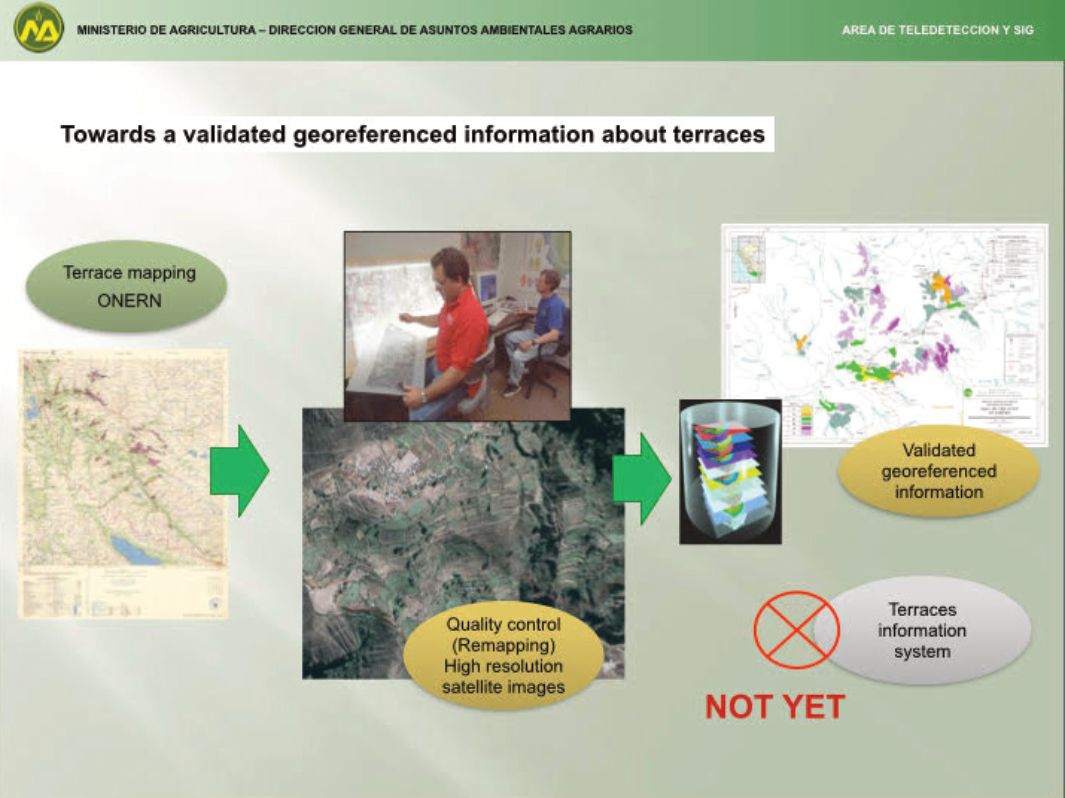
The Ministry of Agriculture took initiative to continue the inventory work and started to digitise the maps of 1:100,000 from ONERN-INRENA with the marked terraced fields. Then the technicians of the Ministry checked the inventories from the maps georeferencing the areas in satellite images of high resolution. Overlaying both sources they established the borders of the terraced fields in the maps and redesigned the areas and they identified new areas of terraces. There was no field observation of the areas.
2.5. Inventory of Andenes by Agrorural (BID contract) in 2012
The inventory overseen by Agrorural and its Terrace Project funded by the Interamerican Development Bank (IDB) aimed at quantifying the amount of hectares with terraces in 11 regions: Arequipa, Moquegua, Tacna, Junín, Cusco, Puno, Amazonas, Apurimac, Lima, Ayacucho and Huancavelica. It is an approximation to the terraced land extension using the satellite images for interpretation. The images are obtained from Google Earth high resolution of 2.5 m based on the registers from Quickbird satellite of Digital Globe. There has been no validation on site – different to ONERN.
The difficulties of the contract with a consortium of institutions led by DESCO has been that the inventory team had to identify microareas of terraces in a huge area of 11 regions widely spread and for some areas the previous data were not available. Also a difficulty is when the specialist interprets the images which were taken in different seasons, which means that the vegetation offers different colours and shades, which requires a good understanding about ecosystems to be able to judge the presence of terraces or not. The inventory of Agrorural presents an amount of 340,719 ha for the 11 regions, about 75% in use and about 80 T ha without use. The regions of Lima, Cusco, Apurimac and Ayacucho show the largest area of terraces (between 45 and 55 T ha each). For Puno the result is to count with 23,875 ha and 87% still in use. ONERN in 1992 identified 16,770 ha of terraced fields for Puno. A study team of the Highland University in 1992 had a result of 122,882 has (Díaz Zeballos & Velásquez Coaquira, 1992), more than 5 times of the data shown by the satellite based inventory.
Why is this difference for a region like Puno, which stands as an example for other regions? One has to do with historic difference, outmigration of the village youth to search for education and jobs in the urban centres abandoning cultivation areas. Work in mining, tropical agriculture, tourism, urban jobs have offered better opportunities for subsistence and income than agricultural production with low market prices. Another reason is with the difference of looking at mountains with own eyes (three-dimensional) instead of screen interpretation. If we exclude the abandoned areas from colonial times it may seem that they are not part of an inventory – as it seems that these areas are difficult to reconstruct and put into use – too costly, no labour force, no irrigation canals habilitated, no idea about the potential of crops for these areas.
3. Methods and Instruments Used in the Inventories’ Comparison
In the form of a synopsis we have compiled the comparison of the different inventories we have been able to follow up revising articles, powerpoints of relevant actors, personal conversations, project documents and websites with relevant information (Table 1).
4. Differences in the Inventories and Undetected Terraces
As we want to show the benefits and limitations of the existing inventories, we have selected 5 different areas, where we compare the findings for abandoned or used terraces with recent satellite imagery and their interpretation. We have not selected the most visible and well-known terraced areas in Lima or Cusco, as these areas have been previously visited and mapped. Since we hope to give greater visibility to the thousands of terraced hectares that remain to be detected in the different scenarios of the Andean rural environment, moving towards a more precise inventory.
For this reason, we have chosen three areas in Puno (the island of Taquile in Lake Titicaca, province of Puno, terraces in the province of Azángaro and in the province of Sandia, on the eastern slope of the Andes), in Arequipa an area little studied near the Pacific Ocean coast (Loma Corta, near Ocoña) and in Chachapoyas (Amazonas) an area with subtropical climate (Figure 2). The Sandia area is an area on the eastern slopes of the Andes at 2,200 m altitude with a humid climate and close to the tropical forests of Madre de Dios. Azángaro is part of the Altiplano at an altitude of 3,900 m. Taquile is an island near Puno on Lake Titicaca at an altitude of 3,800 m. Loma Corta is an area on the Northwest Coast of Arequipa at an altitude of 400 to 900 m with an arid climate. And Chachapoyas belongs to the Amazon Region at an altitude of 2,300 m.
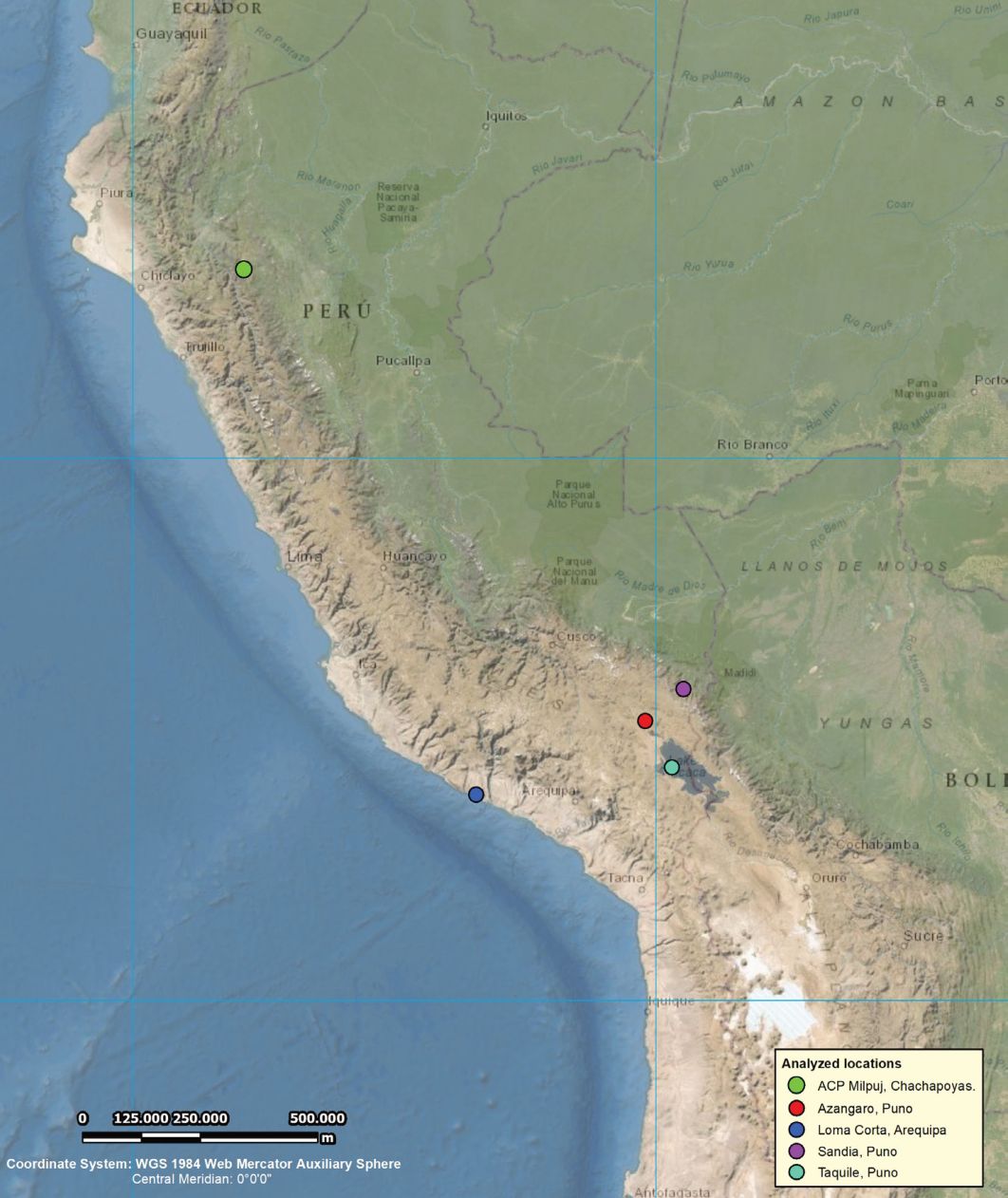
The satellite images which we have used to review the terraced landscapes (in use or abandoned without further classification) is based on Google Earth, Zone Peru, record from 15/10/2020 prepared all by our co-author Jorge Novo from Huelva, Spain.
We chose Puno as the team of the Waruwaru research project published an inventory of the terraces in 1992 arriving at 122,882 ha in total, most of them abandoned. Agrorural identifies 23,706 ha of terraces, 20,706 ha in use and 2,829 ha abandoned. We get to the conclusion that most terraces in Puno are abandoned and that we estimate a similar extension as Diaz and Velasquez (1992).
A. Island of Taquile, Amantani District, Lake Titicaca, Puno
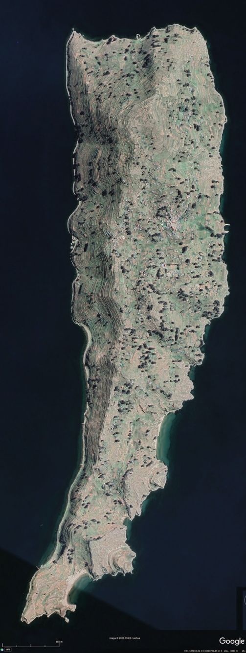
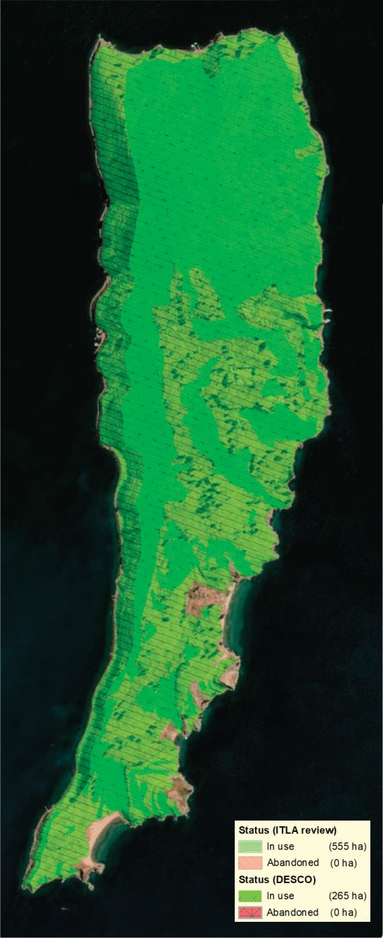
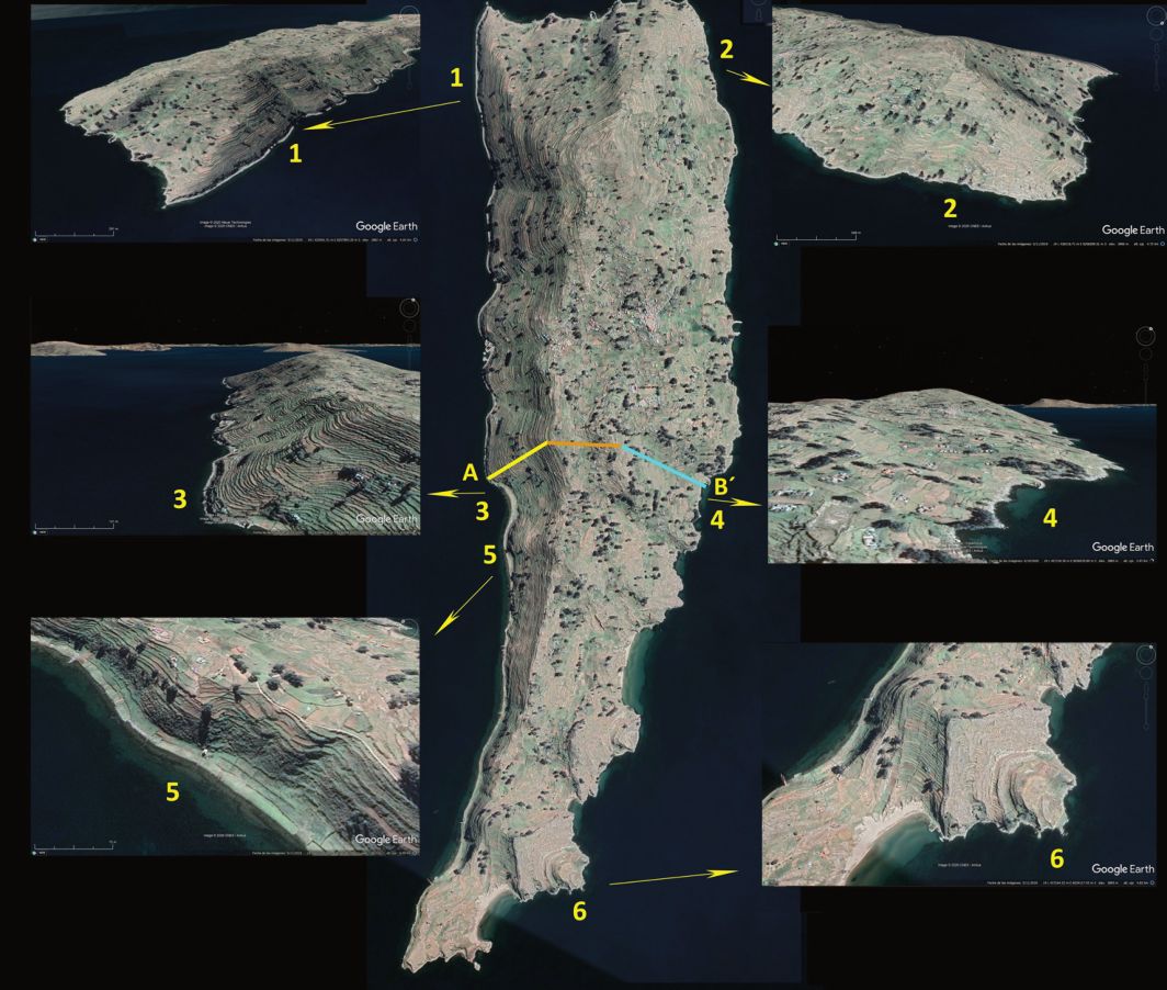
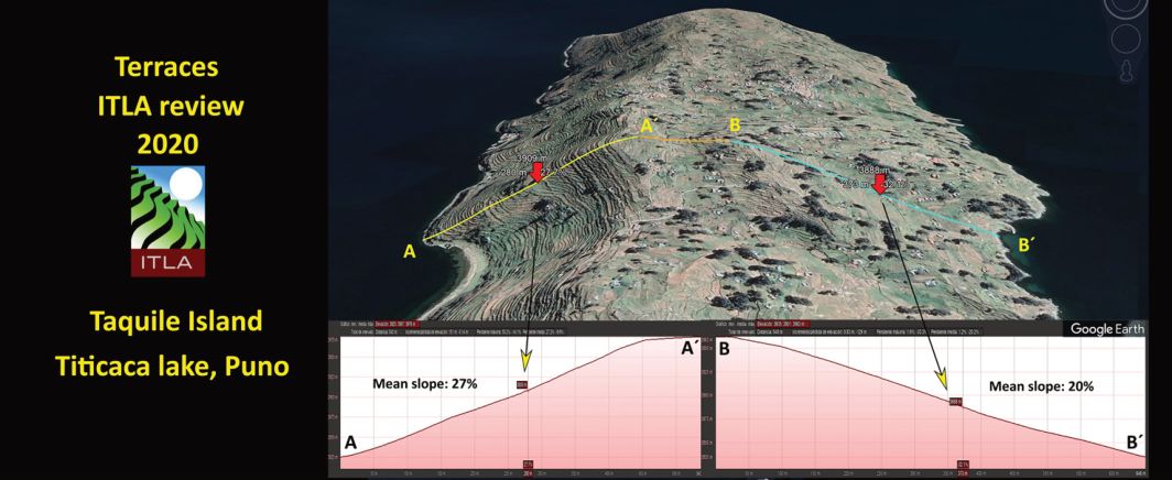
First study area for comparison is the island of Taquile. The DESCO team maps only terraced areas in use with an extension of 265 ha, while our review shows more than twice the extension, 555ha (Satellite Images from Taquile: Figure 3, Figure 4, Figure 5).
B. Azángaro, Puno
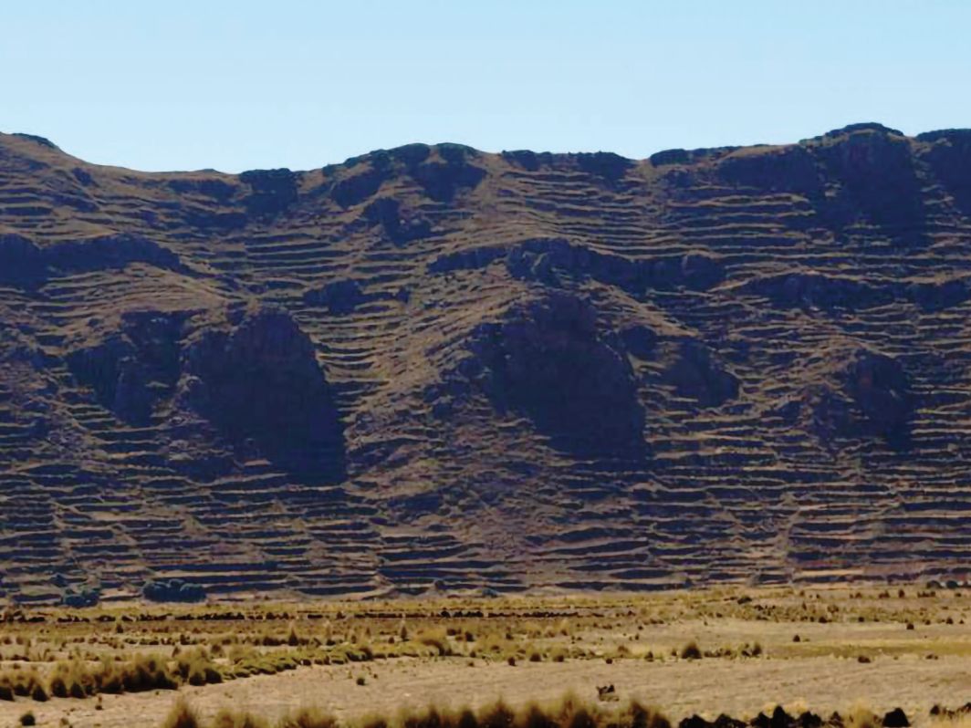
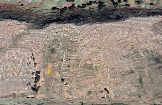
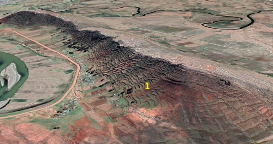
As we can see from the examples many areas of terraces – in use or abandoned – do not figure in the Agrorural inventory. When we travelled to visit communities that are part of the Andean project on Food Sovereignty (PASA – www.pasandes.net) in Macusani we saw the many mountain ridges and the mostly abandoned terraces along the slopes near Azángaro. As the Altiplano is considered one of the domestication centres for potatoes and other tubers, it is the terraced fields, which offer special conditions for the growth and control of the tubers. The terraces in the Altiplano were for tubers and quinua or kiwicha (Andean food plants), and not for maize as it was in Cusco or Arequipa at lower altitudes. Diaz and Velasquez in 1992 list for Azángaro 22,576 ha of terraces, while Agrorural lists 532 ha in total, 422 ha in use, and 110 ha abandoned: a difference from 1:40 (Satellite Images from Azángaro: Figure 6, Figure 7, Figure 8, Figure 9 and Figure 10.
C. Sandia, Puno
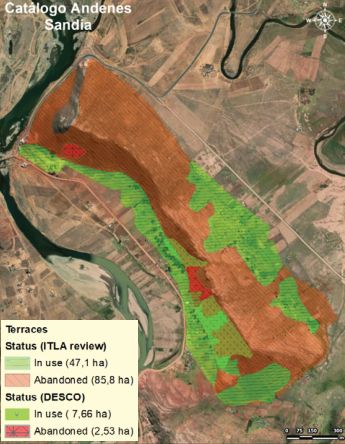
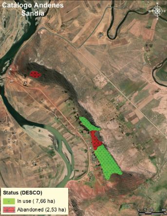
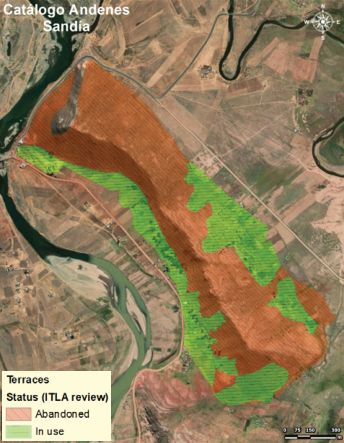
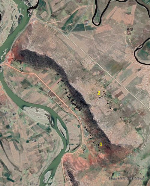
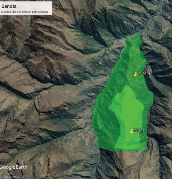
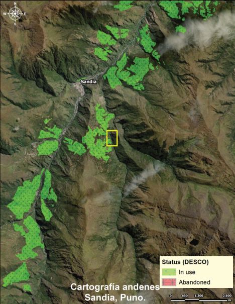
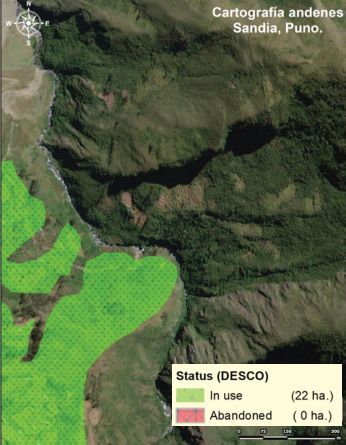
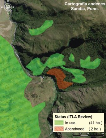
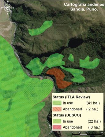
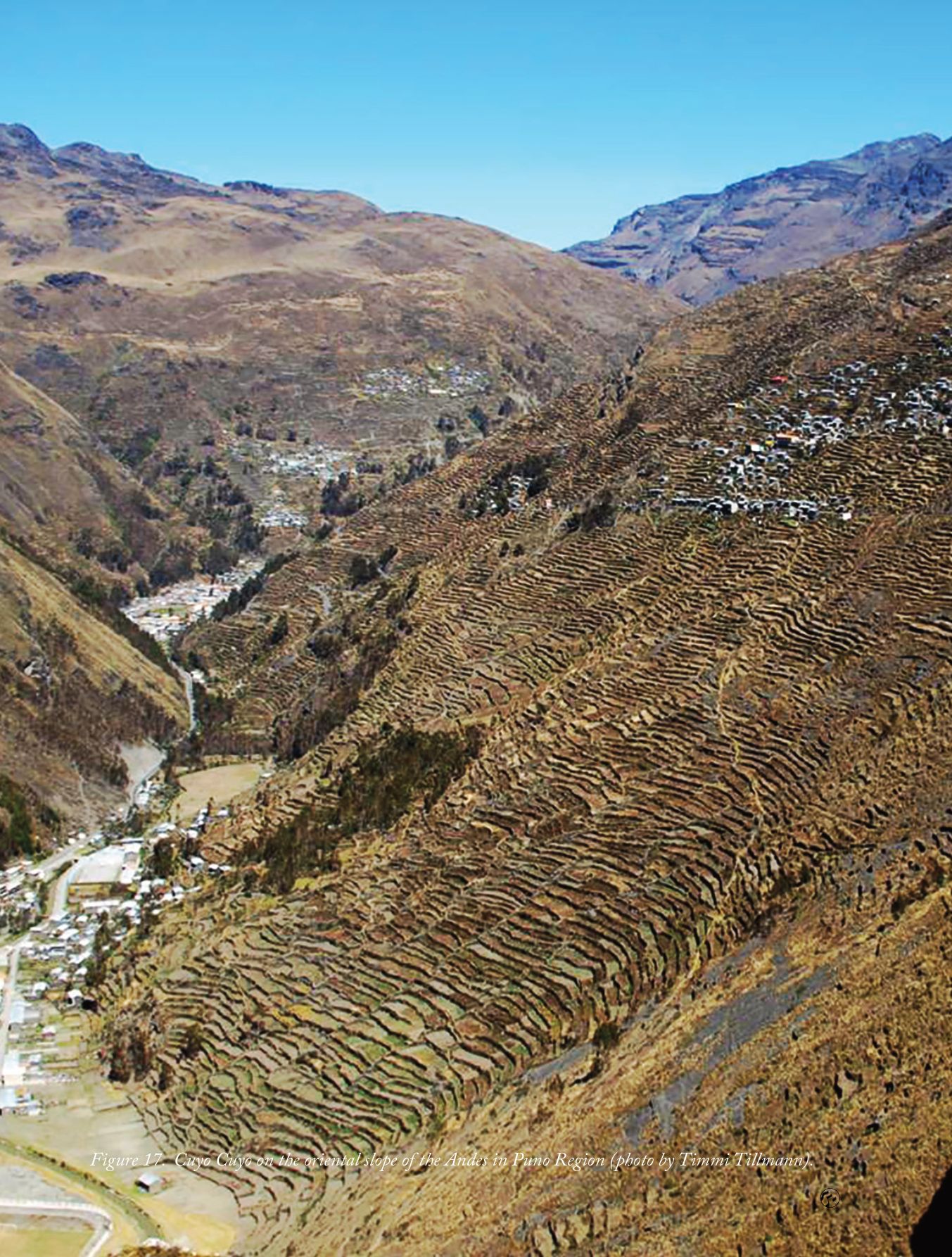
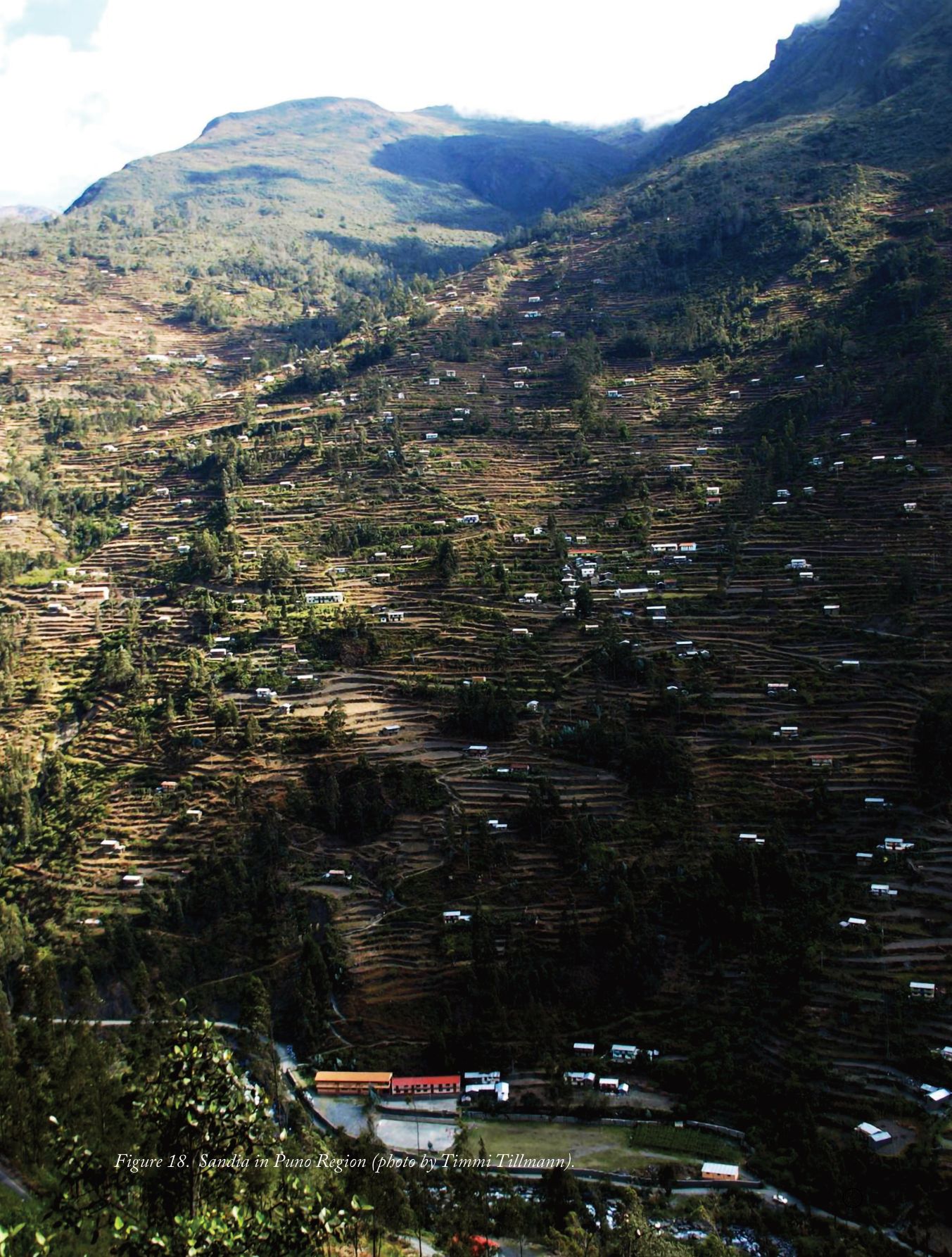
The third area in Puno is in Sandia (further down from Cuyocuyo) on the oriental slopes of the Andes where the mountains consist of endless terraces and the houses of the families are spread all over the slope on the terraces. Schools and community centres are built on terraces too but the homes are spread on the fields. Many terraces are still in use, but many areas also of abandoned terraced fields are not included in the inventory.
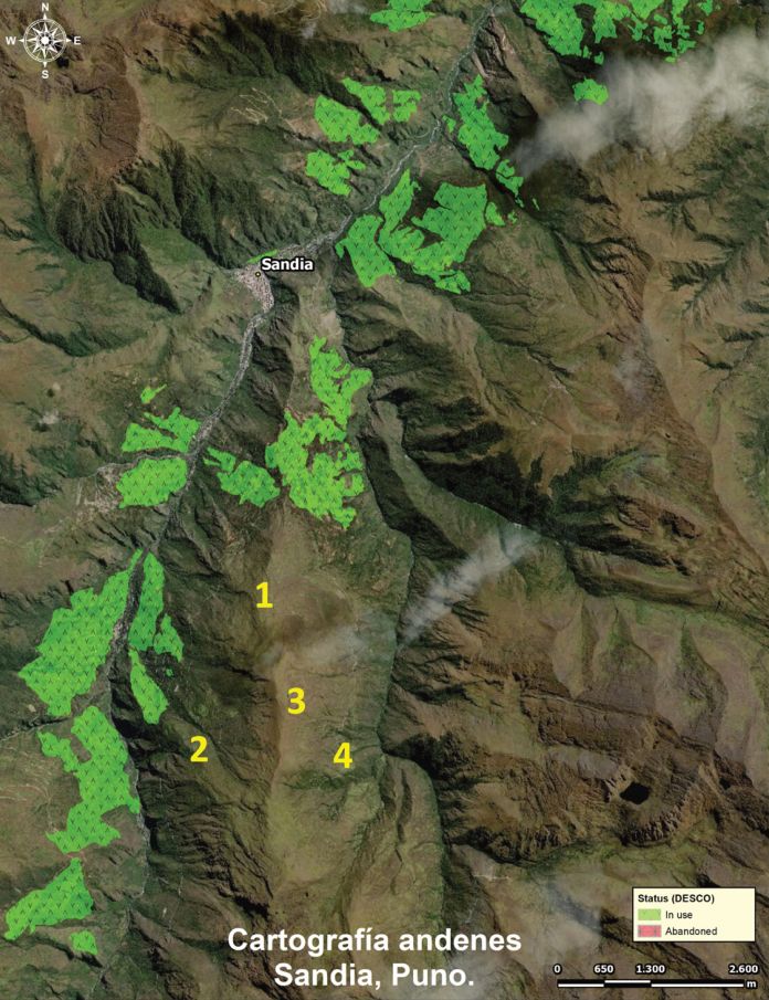
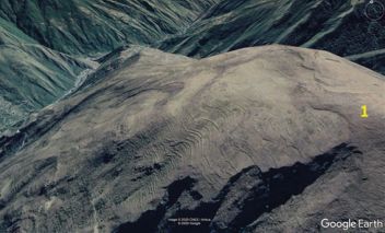
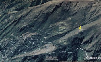
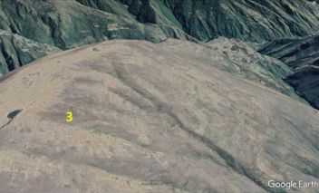
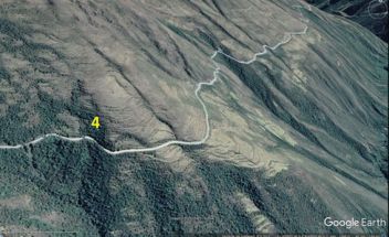
Diaz and Velasquez list for Sandia a total of 19,976 ha, while Agrorural lists 781 ha, 681 ha in use and 100 ha abandoned (Satellite Images from Sandia, Puno: Figure 11, Figure 12, Figure 13, Figure 14, Figure 15, Figure 16; Cuyo Cuyo and Sandia in Puno: Figure 17).

D. Loma Corta, Caraveli District, Arequipa
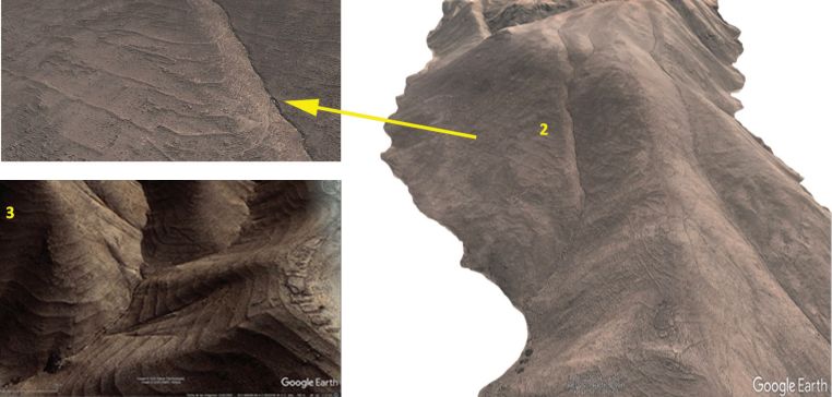
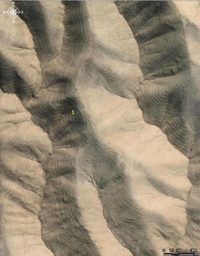
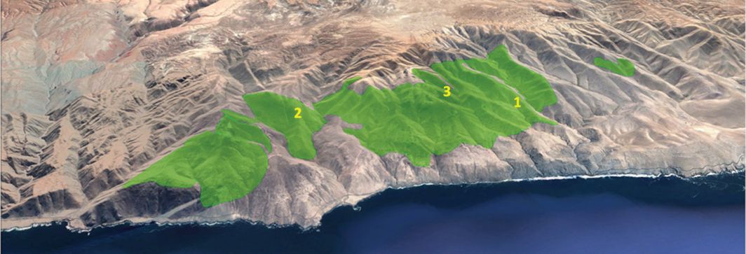
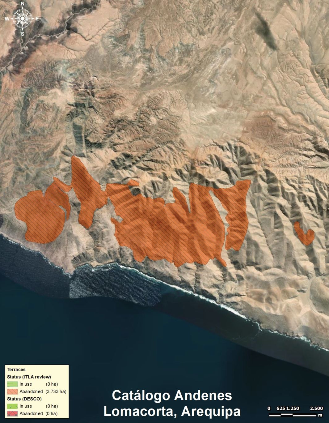
The fourth area of Loma Corta, which we selected is near the Coast in Arequipa, Caraveli close to Ocoña. The river from Cotahuasi, where there are extensive areas of terraced fields, runs into the Pacific Ocean in Ocoña. The Pre-Inca societies managed from the Coast to the highlands a diversity of agricultural fields. This area of 3,377 ha is well designed but long time abandoned; it was not included in the Agrorural inventory prepared by the Desco consortium. It is easy to identify the area as the dry zone of the Western Andean slope shows no vegetation or vegetation only exists when the clouds come form the ocean and form the green coverage of the Lomas (like the ones in Atiquipa not far from Loma Corta) (Satellite images from Loma Corta: Figure 19, Figure 20).
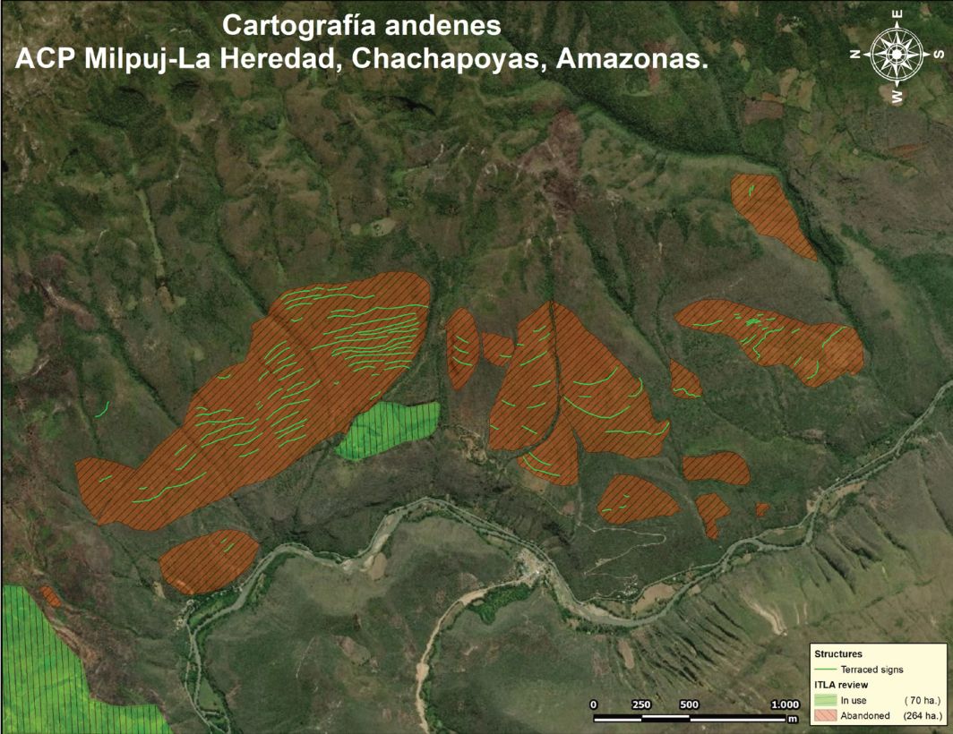
E. Chachapoyas
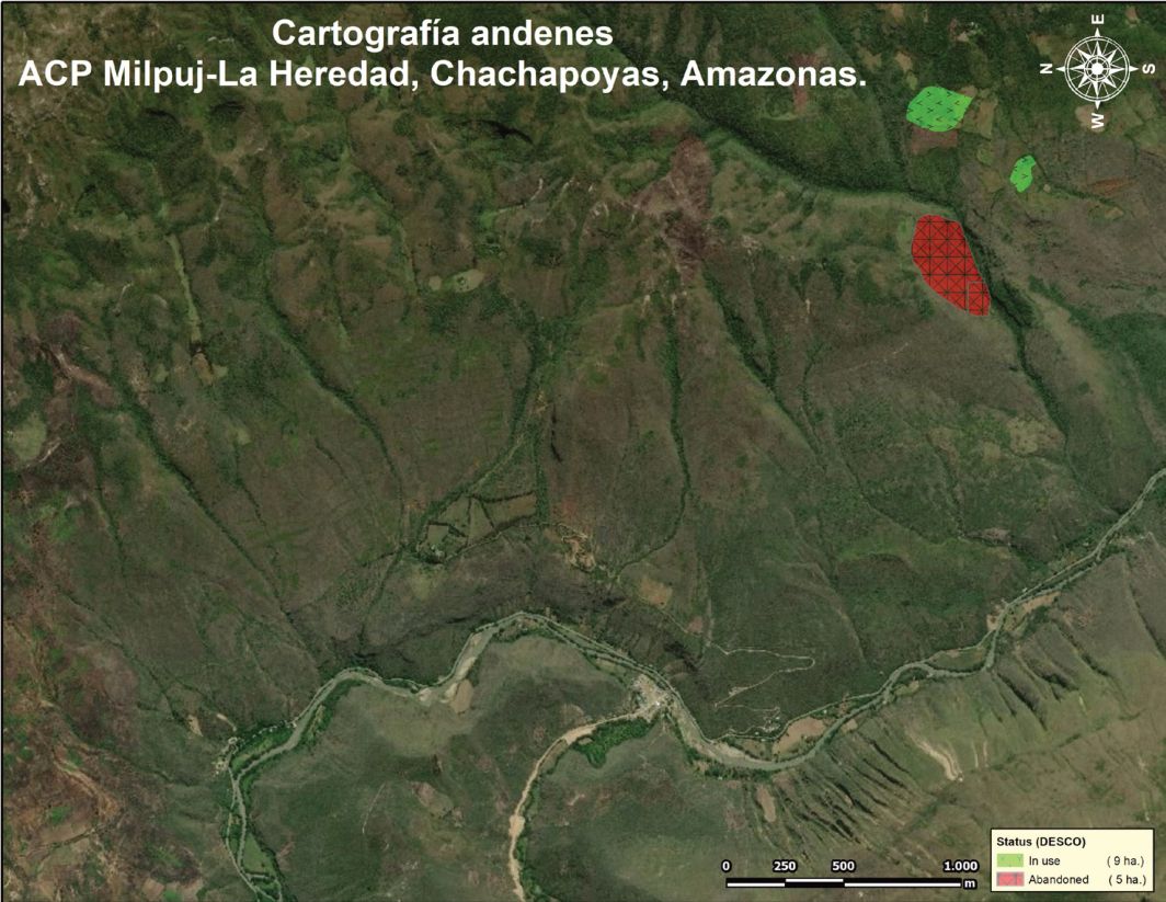
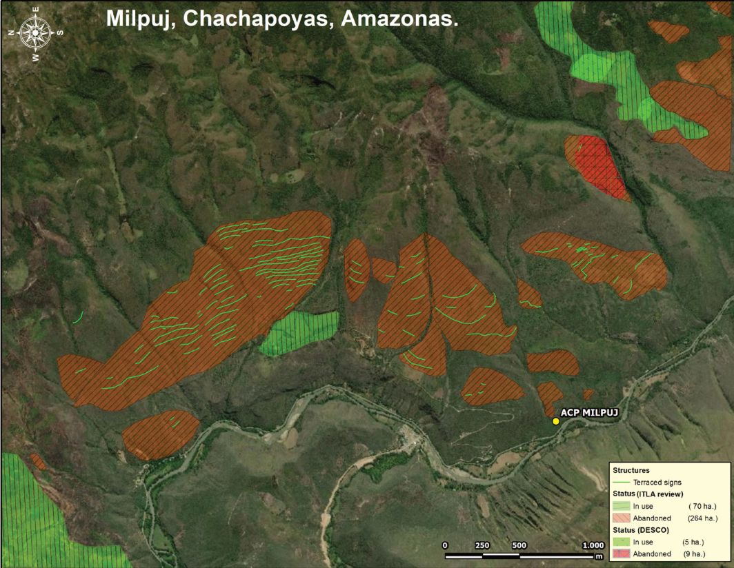
Finally we have chosen an area in Chachapoyas (Amazonas region), which has not been in a priority for Agrorural, as the terraces from Inca and Preinca times are located especially in the South and Center of Peru. It is just an example for terraced fields, which are more difficult to identify (without LIDAR) as the fields are overgrown with the tropical rainforest vegetation (Figure 21, Figure 22, Figure 23). We got information about Chachapoyas from Pedro Heredia, who also sent us an interesting study by Ana Paula Guzmán Méndez (2018) about the terraced fields in Chachapoyas. While Agrorural identified 14 has we marked a total of 334 has with about 80% abandoned terraces.
5. Towards a Consistent Inventory of Terraces in Peru
5.1. Recent steps
For the Second World Congress of ITLA in Cusco in 2014 we prepared regular coordination meetings from 2011 till 2014 where also Agrorural staff was involved. Through this process of involving more than 30 professionals we could identify terraced communities in Central and Southern Peru to be visited and also to take part in the Second Congress with peasant delegates. We attended also the meetings of the scientific committee of the Terrace Project of IDB and Agrorural and learned about the inventory project. Ahead of the Congress in May 2014 (harvest time) the organising team formed by CBC, ITLA, Catholic University of Lima, University of Cusco, Cusichaca Trust and Condesan organised field trips to terraced areas in Lima (Cañete Valley), Arequipa (Colca Valley), Ayacucho (Andamarca) and Cusco (Vilcanota Valley and Moray). During the Congress we created a forum for the peasant delegates and a Community Fair with local seeds and crafts. More than 80 men and women from terraced communities joined the Congress and got involved in the discussions of the 5 working groups with the topics of water and soils, agrobiodiversity and food sovereignty, social organization and cultures, traditional and modern technologies and governance and policies.. The rural delegates were the protagonists of the ITLA Congress in Cusco reflecting the priority of the terrace dwellers in the discussions about the future of terraced landscapes. One conclusion of the Vth Congress has been to form an alliance of terraced communities in Peru as one national network to continue coordinating with ITLA, the international alliance of networks. The CBC continued to convene the delegates of farming communities in Southern Peru, but this got interrupted by the death of Mourik Bueno in 2019, the promoter of the ITLA Peru network, and in 2020 by the Coronavirus outbreak. Since June 2020 the CBC under a new leadership (Carlos Herz) has undertaken action to build the alliance for terraces and food sovereignty (ITLA-ASA) in Peru and is engaged not only to publish the map of terraces of Peru in cooperation with AGRORURAL but also to develop an international seminar on terraced landscapes in 2022 and preparatory workshops and conferences with community delegates, professionals and with young academics which started in 2020. 5 conferences from Nov 20 till May 21 deal with Landscape, Infrastructure, Agroecology, Food Sovereignty and the Inventory of terraced lands.
5.2. Constraints and future steps
Inventories are always in process, as the land use undergoes changes and the base material of aerial photographs, field visits or satellite imagery may be from years before and recent images have higher resolution, develops rapidly differently increasingly accurate recording devices (Lidar, gravimetry, chromatic band detectors, thermals, etc).
Migration affects the use of terraced land: cities, major or minor human accumulations, industries, mining, mechanized farms that abuse water, polluting and destroying life, throwing garbage, misuse agrochemicals, not carrying out adequate treatments to contaminated water, over-exploiting aquifers, contaminating them with pesticides, and other by-products of human activities, etc. In short, a society with a tendency to the commoditisation of nature, that due to lack of knowledge and / or technologies to mitigate its impacts, in the worst case with them but with irresponsible behaviour by not applying them, they cause a resentment in the quality of the rural environment, water, crops and nature in general, especially affecting vulnerable rural communities. The low prices of agricultural products at origin, and the throttling action of intermediary markets that lower prices at origin even more, give the finishing touch to the situation. The terraces, which require a large amount of labour, are abandoned because they are not profitable.
The new systems of production under purely extractivist capitalism systems pollute air, waters and minds, take away water for their needs letting fields un-irrigated producing an exodus of young people to work in cities, large, industrialized farms, mines, etc. looking for a better quality of life as the mass media tells them.The climate crisis produced by the impact of industrialization on our weather conditions creates new conditions for agricultural fields – droughts and less rain affect crops of the peasants, higher temperatures move crops like potatoes in higher locations. This means that terraces are not fixed but change over time (Denevan, 2001) and in history have impacted with ecological, political and social factors on the abandonment of terraced fields. Watching aerial photographs (Bridges, 1991) and satellite images comparing different decades we get an idea of the economic and social changes of the agricultural terraces – the areas and biodiversity.
The evaluation team of the IDB funded inventory with Agrorural (Programa Andenes 2014) remarked following constraints: • The project was formed as part of the Rehabilitation Program under the umbrella of
Agrorural, an extension agency of the Ministry of Agriculture. This project established a scientific advisory board with excellent scientists, but this board did not have much influence on the project itself. They were called once in a while to comment on reports and activities, but they did not have a specific task to guide the project activities. • The inventory and the project was formulated as a technocratic process of mapping
terraces, it was neither conceptualised as a multisectoral approach involving more agencies for aspects of identity and the socio-cultural dimensions nor the local people were involved in the process, as the inventory was done on screen with satellite images. • The outcome to identify priority regions for rehabilitation of terraces did not
consider how to manage the cultural diversity and to use the ecological resources, this was not part of the considerations of the project. The hydrology of where to obtain the necessary water to irrigate the terraces was not part of the prioritization. The ancestral and traditional Andean water harvesting knowledge, sustainable and with effectiveness demonstrated during millennia of application, are in danger of extinction, since the true connoisseurs, the elderly people of the rural environment, die without young people to whom they bequeath their knowledge, the irrigation channels are dry, they all went to the universities learning to make concrete works. • The governance of the project itself was weak, as the staff did not take initiative and
also was changed during the duration of the project leading to little impact in the field and the lack of coordination with important actors (local leaders, activists from NGOs, researchers and extensionists). • The IDB evaluation stated that the inventory were just electronic maps but to be a
practical tool it required to count with a guide or manual on how to use the inventory and how to focus on the rehabilitation of the terraces in collaboration with the local communities (Guarín, 2015).
Finally the whole inventory was not published as the project finished, the expert from IDB moved away from Lima and the whole project got stuck. Only now Agrorural and the Center Bartolome de las Casas as leading NGO of ITLA Peru have recovered the material of the inventories and published the inventory of terraces, which allows to identify the communities for a dialogical process of producing on abandoned fields the food crops people need and enjoy5.
6. Conclusions
The reports of the Agrorural Inventory of Terraces indicate a selection of districts and terraced areas to be prioritised for reconstruction, even calculating the costs involved. It has been an important effort to highlight the mountain places, remote and at small scale with terraces, which are the heritage of humankind. But not all areas have been identified, so new tasks and activities are needed for the visibility of terraces and for the recuperation of valuable agricultural land in Peru. Instead of 340 T ha of terraces we estimate a minimum of 1 million ha of terraces including all types of terraces in the different regions of Peru.
To overcome the limitations of the inventory from 2014 it would need a larger project of mapping specialists using LIDAR, satellite image interpreters, people in the field including anthropologists and archaeologists, agronomists and hydrologists, etc. to contact the local people and work with them to produce participatory multidimensional maps and produce visible results and local voices to achieve an impact on the national policy to promote farming communities in the Andes and to prepare local reconstruction plans with a vision of food sovereignty (Camara & Bueno de Mesquita, 2019).
There should be 2 dimensions of the promotion of terraces – on one side, Peru needs either an own institution because of the dimension of the task or additional official funding for terraced lands within Agrorural with government funds (instead of a project that has only temporary staff and not a continuous funding; the donor agency’s staff can be moved abroad and the project stops), who gives support, identifies terraced land and communities, promotes organic food production for the local community. On the other side, an alliance of communities and activists is necessary who accompany community initiatives and develop innovative forms and contents of terrace building and use. The communities could form terraced land observatories to monitor the situation of the land and water and suggest measures to recover abandoned slopes for organic production.
This requires not only the participation of the peasant groups, but also a shift of the paradigm of development towards food sovereignty in favor of the local circular economy based on the conditions of mountain ecosystems with diversity (and not urban nor plain ecologies). A shift also about the perception of terraced lands as remote and marginal with poor quality of products, it is the opposite: the optimum use of natural resources by human collectives. The principles of agroecology lead to the adoption of an Andean principle of reciprocity between humans and nature as part of the decolonisation of an imposed development model.
Acknowledgment
We are thankful for the support from the specialists who worked with the inventory team of Desco and the consortium and provided us access to the inventory data and reports. The satellite images were revised by Jorge Novo and he prepared the detailed maps with the comparison of areas. Thanks to Wagner Guzmán (from Chachapoyas) who sent us the study prepared by his daughter Ana for the Science Fair in 2018.
References
- Agrorural (2021) Andenes para la vida. Inventario y caracterización de andenes en los Andes tropicales del Perú. Cusco: CBC
- Alberti, F.; Dal Pozzo, A.; Murtas, D.; Salas, M.A.; Tillmann, T. (eds.) (2018) Terraced landscapes: choosing the future. Proceedings of the Third World Meeting of ITLA. Venice: Veneto Region.
- Bridges, M. (1991) Planet Peru – Fotografien. Frankfurt: Zweitausendeins.
- Camara, L.; Bueno de Mesquita, M. (2019) Terraced landscapes in Peru: Terraces and social water management, in World terraced landscapes: History, enironment, quality of life. Cham, Switzerland: Springer Nature.
- Cook, O.F. (1916) Stair case farms of the ancients. Astounding farming skill of the ancient Peruvians, who were among the most industrious and highly organized people in history. Washington D.C.: National Geographic Society.
- De la Torre, C.; Burga, M. (1986) Andenes y camellones en el Perú Andino. Historia, Presente y Futuro. Lima: Concytec.
- Denevan, W. (1988) Measurement of abandoned terracing from air photos, Colca Valley (Yearbook, Conference of Latinamerican geographers). Austin: University of Texas Press.
- Denevan, W. (2001) Cultivated landscapes of native Amazonia and the Andes. Oxford: Oxford University Press.
- DGAA (2011) Del inventario naconal de andenes. PPT. Lima: Minagri
- Díaz Zeballos, C.; Velásquez Coaquira (1992) Inventario de infraestructuras agrícolas andinas en Puno, Perú, in Avances de investigación sobre la tecnología de Waru Waru. I. Infraestructura, J. B. Palao, (ed), pp. 17-37. Puno: Programa Interinstitucional de Waru Waru, PELT/INADE - IC/COTESU.
- Donkin, R.A. (1979) Agricultural terracing in the aboriginal new world. New York: Viking Fund Publications in Anthropology.
- Felipe Morales, C. (2004) Balance de las investigaciones sobre andenes en el Perú, in: Conservación y abandono de andenes. Lima: Universidad Nacional de la Molina, Universidad de Haifa.
- Guarín Corredor, F. (2015) Informe final de la actualización del mapa del inventario de andenes. Lima: Agrorural BID.
- Guzmán Méndez, A. P. (2018) Terrazas y andenería en el Perú. Conocimiento ancestral para enfrentar un futuro incierto. Google Science Fair. https://gestion.pe/tecnologia/google-science-fair-adolescente-peruana-ganadores-latinoamerica-nndc-265330-noticia/
- IGN (2015) Historia del Instituto Geográfico Nacional. Lima: Instituto Geográfico Nacional.
- Johnson, G. (1930) Peru from the Air. New York: American Geographic Society.
- Kendall, A.; Rodríguez, A. (2015) Desarrollo y perspectivas de los sistemas de andenerías en los Andes Centrales del Perú. Cusco, Lima: Centro de Estudios Regionales Andinos Bartolomé de Las Casas, Instituto Francés de Estudios Andinos. https://books.openedition.org/ifea/6110
- Lambruschini, A. (2014) Programa Andenes. Seguridad alimentaria y cambio climático. Lima: Agrorural.
- Massón, M. L. (1993) Contribución al conocimiento de los andenes. Arequipa: SEPIA V.
- Mejía, A. M.; Mejía, A. R.; Arata, A.; Camiloaga, F. (2014) Aportes a la construcción de una propuesta metodológica para la caracterización e inventario de sistemas de terrazas y andenes. https://es.slideshare.net/InfoAndina/metodologia-andenes-desco
- Mujica, E. (1997) Los andenes de Puno en el contexto del proceso histórico de la Cuenca norte del Titicaca. Simposio Conservación y Abandono de Andenes. Lima: UNALM.
- Pajares, G. (1989) Anales del Segundo taller seminario: Recuperación de andenes y otras tecnologías tradicionales: problemas y soluciones. Lima: CEPAL.
- Programa Andenes (2014) Evaluación del Proyecto Andenes - Conclusiones y recomendaciones. Lima: Agrorural.
- Programa Andenes (2014) Resumen ejecutivo - Inventario y caracterización de andenes en 11 regiones del Peru (Arequipa, Moquegua, Tacna, Junín, Cusco, Puno, Amazonas, Apurimac, Lima, Ayacucho y Huancavelica). http://andenerias.blogspot.com/2014/12/resumen-ejecutivo-inventario-y.html
- Torres Guevara, J. (2014) La Biología de las Terrazas: la agrobiodiversidad de los Andenes. https://cupdf.com/document/la-biologia-de-las-terrazas-la-agrobiodiversidad-de-los-andenes.html
Rights and permissions
Open Access. This article is licensed under a Creative Commons CC BY 4.0 license, which permits use, sharing, adaptation, distribution and reproduction in any medium or format, as long as you give appropriate credit to the original author(s) and the source and indicate if changes were made.
About this article
Cite this article
Tillmann, T., Novo, J., & Epiquién, M. (2020). Inventories of Terraced Landscapes in Peru. The Journal of Terraced Landscapes, 1(1), 34–71. https://doi.org/10.5281/zenodo.5215341
- Published
- October 2020
- Issue
- Volume 1, Number 1
- Journal
- The Journal of Terraced Landscapes, ISSN 2754-7612 (Online)
- Archive
- Zenodo record 5215341
- Peru
- inventory of terraced landscapes
- mapping
- aerial photographs
- remote sensing imagery
- inventory of terraced landscapes
- mapping
- aerial photographs
- remote sensing imagery